

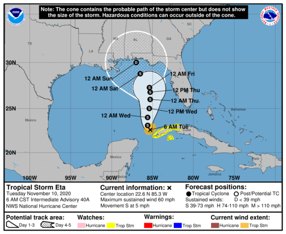
Nov 10, 2020, 4:33 AM— After coming ashore in the Florida Keys overnight, Tropical Storm Eta is now hovering just north of the Yucatan Channel and is set to re-strengthen as it meanders over the south-eastern Gulf of Mexico on Tuesday.
Flash and urban flooding will be possible for the Bahamas and the remainder of southern and eastern Florida over the next few days with south Florida and western Cuba also at risk, according to the National Hurricane Center.
“Eta is stationary, and little overall motion is forecast today, with a slow northward motion is expected tonight through Thursday,” the NHC said in an advisory published Tuesday at 4 a.m Eastern Standard Time. “Maximum sustained winds are near 50 miles per hour (85 km/h) with higher gusts. Some strengthening is forecast during the next day or two, followed by weakening likely starting on Thursday.”
Neighborhoods flooded across several parts of South Florida, including Miami’s Brickell Avenue financial district, where several banks and investment firms have their offices.
“The biggest problem with this system is going to be the rainfall,” said Dan Kottlowski, a meteorologist at AccuWeather Inc. “A lot of places are going to have days of pouring rain.”
The official hurricane center track forecast currently takes Eta on a u-shaped path through the eastern Gulf of Mexico. Its threat to offshore oil and natural gas production will probably be low, Kottlowski said.
Eta adds to a record-breaking Atlantic hurricane season that’s seen hundreds of deaths, billions of dollars in damage, and a total of 28 storms. So many storms have formed that the hurricane center used up all the names on the official list by mid-September and has had to use Greek letters to designate subsequent systems. Eta is the 12th storm to hit the U.S. this year, an all-time high.
Eta made landfall in Florida at around 11 p.m. local time on Sunday and has since moved westward near the Dry Tortugas, a group of islands at end of the Florida Keys that’s home to a 19th century military fort. Across Florida, more than 9,000 customers are without power, according to PowerOutage.us, a website that tracks blackouts.
The storm has already left a path of destruction through Central America and the Caribbean. Eta previously made landfall in Cuba early Sunday with 65-mile-per-hour (105-kilometer-per-hour) winds and heavy rains. The storm killed more than 50 people across Central America last week, and more than 100 others are missing after it struck that region as a major hurricane, according to the Associated Press.
Oddly, because tropical storms spin counter-clockwise, some of the highest wind gusts have been hitting eastern Florida far from Eta’s center, Kottlowski said. Also, winds at the edge are traveling over water, so there is nothing to slow them down before they hit the eastern coast.
Part of what is keeping Eta at bay through the course of the week is a large dome of high pressure that could generate record high temperatures across much of the eastern U.S. this week, said Jim Rouiller, lead meteorologist at the Energy Weather Group. Temperatures will reach 75 degrees Fahrenheit (24 Celsius) Monday in Chicago and 74 in New York, the National Weather Service said.
Eta will likely make landfall again somewhere between Tampa and the Florida Panhandle on the state’s west coast by as late as Saturday.
For the U.S., Eta’s destruction probably won’t match the tragedy still unfolding across Central America. The U.S. economic tally will probably be less than $100 million in insured losses, said Chuck Watson, a disaster modeler for Enki Research.
Florida Governor Ron DeSantis has declared an emergency in advance of Eta. Beyond Eta, the hurricane center is tracking two other potential systems, one in the Caribbean with a 50% chance of becoming a storm in five days and the other in the central Atlantic with an 80% chance.
“It’s not over,” Rouiller said. “I think we’re going to have another one. The ocean temperatures are warm enough to be supportive of hurricane growth.”
(Updates with new details.)
–With assistance from Jonathan Levin and Serene Cheong.
Top Photo: A man during heavy rain and wind as tropical storm Eta approaches south of Florida, in Miami, Florida on November 8, 2020. Photographer: Chandan Khanna/AFP/Getty Images.
Topics Florida Catastrophe USA Natural Disasters Windstorm Flood Hurricane
Was this article valuable?
Here are more articles you may enjoy.
 Investment Funds File New Suits Over Lighthouse Insurance Collapse in 2022
  Former Congressman Charged After Collision with State Trooper in Florida
  California Sees Two More Property Insurers Withdraw From Market
  North Carolina Adjuster and Son Charged With Embezzlement in Roof Jobs